
- When
- Sat, January 16 2021
- Where
-
Virtual Sacramento
Sacramento - Time
- 12:00 pm
- Admission
- Free

Description
What is the 2040 General Plan, and what does it mean for neighborhoods throughout the city of Sacramento? This webinar will explain what a General Plan is, what this update means, and discuss its effects on Sacramento’s historic resources and neighborhoods.
The City of Sacramento is updating its General Plan, including the housing element and land use map. This revision includes some very dramatic changes in how properties are zoned, in order to facilitate creation of new housing throughout the city of Sacramento. That includes a simplification of land use categories, and elimination of maximum density limits, replaced instead by FAR (Floor Area Ratio) which limits the amount of space a building takes up on its lot.
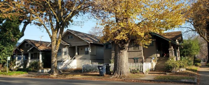
Many elements of the General Plan update sound very much like changes that long-time SOCA (Sacramento Old City Association, Preservation Sacramento’s predecessor) activists advocated for many years, an approach known as “Form-Based Codes,” and some aspects of this system, like permitting multiplex and single-family buildings in the same neighborhood, but with similar size and scale of buildings, reflect the way that many of Sacramento’s historic districts were built more than a century ago, with diversity of building types and styles, but with common height, setbacks, and scale.
However, there were concerns with details of the plan. Many neighborhood associations, including East Sacramento, Land Park, Mangan Park, Elmhurst, and Boulevard Park, have submitted letters to city staff and are hosting online forums to discuss how these changes will affect neighborhoods citywide. Preservation Sacramento provided comments, because the city’s land use map also indicated similar rezoning of residential to commercial use in other historic districts, including economically vulnerable neighborhoods like Alkali Flat and Richmond Grove. The next step is a hearing to discuss a Land Use and Urban Form map, originally intended for review by City Council on December 1 but delayed due to time constraints, on January 19, 2021.
In order to raise some of these issues to a wider audience, Preservation Sacramento will hold an online workshop on Saturday, January 16, 2021, at noon. While this means a short timeline for responses after the meeting, the city’s staff report and final maps will not be available until Friday the 15th.
Find other events tagged under:
Event Categories


The Mansion apartment block is steps from the Capitol on the border of Downtown and Midtown and has nicer-than-most shared spaces. Go check out @themansion_living if you`re looking for a new place!
The Mansion Apartments
1517 H Street > 95814
Downtown/Midtown
Sacramento CA
916-665-4663
https://themansionliving.com/
Record Store Day 2024 is tomorrow, Saturday, April 20th! 👉 @kicksville_vinyl_and_vintage opens at 8am sharp 👈
Kicksville - Downtown 📸
@kicksville_vinyl_and_vintage
931 T Street
Sacramento, CA 95811
Phono Select - South Sac
@phonoselect
2475 Fruitridge Rd
Sacramento, CA 95822
Rocket Records - Midtown
Rocket Records
1002 24th street
Sacramento, CA 95816
The Cave - Arden area
2265 Arden Way
Sacramento, CA 95825
Twelves Wax - Oak Park
@twelveswax
3324 Broadway
Sacramento, CA 95817
@armadillomusic - Davis
207 F Street
Davis, CA 95616
Sacramento Spring 2024 by @wildpoppyandco in Midtown. Go get something new for the weekend!💄
Wild Poppy & Co Boutique
@wildpoppyandco
1008 24th Street
Midtown Sac 95816
Sun+ Mon 12-5
Tue-Sat 11-6
https://shopwildpoppy.com/


